Saturday, February 27, 2016

If a woodpecker lives in the forest, and no one is around to hear it ...

Pileated woodpecked tree - South Deerfield, MA
Photo by Laura Eve-Cowles, 2/27/2016
Pileated Woodpecker
(Audubon Society,
John McKean/VIREO)
We seem to be on an animal jag here (think "the intersection of weather and animal life"), and it's been fascinating. This photo was just offered up by friend of Head in the Clouds Amherst, Laura Eve-Cowles. 

And the cause of all that damage? No, not some errant maple tapping operation. All credit goes to the pileated woodpecker, who excavates deep into rotten wood and dead trees to get at the nests of carpenter ants.

According to Laura, there were two, "the size of pterodactyls," at work on this tree. And she should know - the Eve-Cowles family was named the 2015 Massachusetts Tree Farmers of the Year for sustainable forest management, which creates better habitat for many wildlife species, particularly birds (her forest/farm is in Deerfield and Conway). Thanks for this awesomely bizarre photo, Laura!

Sunday, February 21, 2016

Bobcat, coyote, and bear! Oh my!

Really big bobcat checking out pumpkin (aw, there's a nice kitty!)
Photo by Brendan Trainor, Western MA
And you thought the Land of Oz was frightening! These three photos, captured in the fall and winter by friend of Head in the Clouds Amherst, Brendan Trainor, bring you some of our area's most common (and usually elusive) carnivores. Okay, I confess, I'm taking artistic license there - the New England Black Bear is actually an omnivore. 
Coyote in Snow - by Brendan Trainor
Regardless, you and your pets would do well to avoid all three. 

And just in case you were wondering, I assure you that Brendan survived all three encounters just fine (including crossing paths with that very sizable bobcat). Thanks again for sharing, Brendan. In my opinion, this is the perfect vantage point! 
Bear way too close - Photo by Brendan Trainor

Tuesday, February 16, 2016

Remember when it was winter?

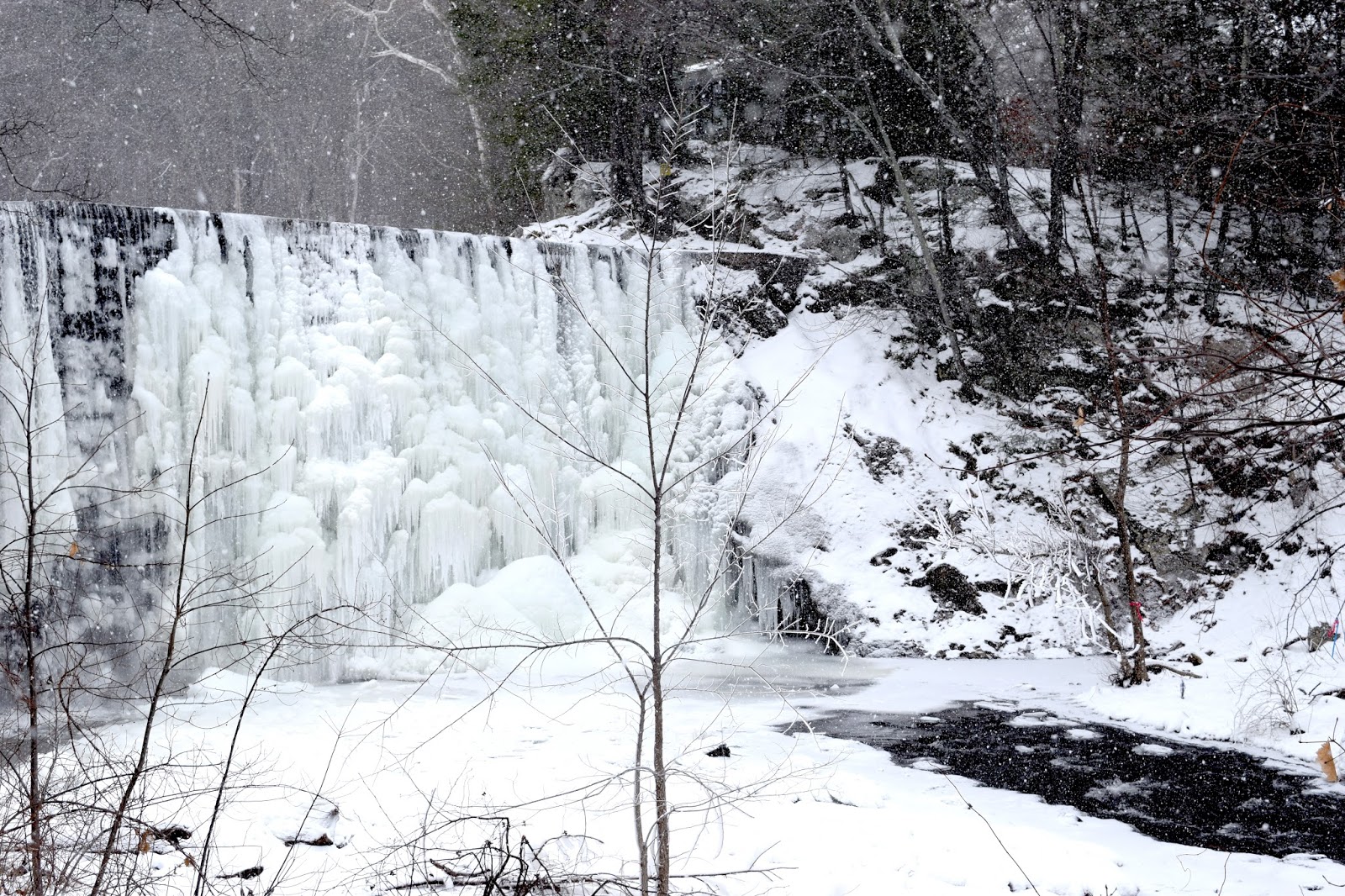
Frozen morning at Puffer's Pond - Amherst, MA
Photo by S. Vardatira, 2/15/2016
Remember when it was winter? Oh, yeah, that was yesterday. :)
Photo of Puffer's Pond Dam right when it started snowing yesterday. If that tree smack in the middle ever disappears, I will be on top of the list of suspects, along with every other photographer who would prefer that view sans tree.

Wild afternoon in the Valley

"Ice ferns" (frost on window), 2/15/2016 (all gone now)
Photo by S. Vardatira, Amherst MA
It’s suddenly gotten wild out there, as high winds sweep across the Valley. There’s no way we go from zero degrees to 50 degrees in 24 hours and not have severe weather break out. Right now, heavy rain with embedded strong southerly winds, and possibly an isolated thunderstorm, is moving quickly northeast across Northern Connecticut into Western and Central Massachusetts. Expect wind gusts up to 50 mph with areas of moderate to heavy rain and isolated thunderstorms. Reports from Bradley have already confirmed wind gusts of 50 mph. Strong enough to bring down tree limbs and power lines, so be prepared. And don’t give in to sudden urges to drive through flooded roads or underpasses.

Monday, February 15, 2016

Everything "winter" headed our way

Frost on Window, 2/14/2016
Photo by S. Vardatira, Amherst MA
Yes, it's hard to believe we could possibly go from the temperature right now (3.3 degrees) to mid-40s tomorrow, but that's the situation. So you know some crazy weather is coming our way in the next 24 hours. 

A WINTER WEATHER ADVISORY is in effect for this afternoon - when all is said and done, we are likely to see 2-3 inches of snow with up to a tenth of an inch of ice accretion. And it's the ice you should be worried about. The whole thing will start off as snow, likely between 4-8 pm this afternoon/evening, then transition to sleet, and then turn to rain/freezing rain overnight. By daybreak Tuesday, it will start to transition to all rain, but with the ground as cold as it is, pockets in the valley could stay frozen, with freezing rain continuing through mid-morning. 

If you can stay planted this evening and overnight, I'd  highly recommend it. I'm going to be grabbing my camera and catching some ice before it all melts away tomorrow. How long I stay outside in these temps is still up for debate...

Stay safe, everyone - and off the road ice!

Friday, February 12, 2016

OMG, it's cold and getting colder! (And what to do about it)

Windswept Farm (from last year's really brutal cold snap, 1/2015)
Hadley, MA - Photo by Sharon Vardatira

For everyone who has been complaining about our lack of winter, now you’ve gone and done it!

EXTREME COLD CONDITIONS will affect our area (and all of Southern New England) over the course of this weekend with dangerous and life-threatening cold wind chills and dangerously cold ambient air temperatures. It’s already cold out there, but it’s going to be even colder soon enough. Fortunately, the frigid snap will not go on too long, as temperatures will moderate over the course of the day on Monday. In fact, we may even see 50 degrees (above zero) for a high on Tuesday!

Before we get to Tuesday, however, we are going to have to survive the weekend. A WIND CHILL WARNING is now in effect from 4 PM Saturday until Noon Sunday for wind chills as low as 20 to 30 below zero with some isolated locations in Central and Western MA hitting 35 below zero. Ambient air temperatures will be 5 below to 15 below zero across our area. Winds will be sustained at 15-25 MPH with gusts up to 45 MPH range, with isolated higher gusts possible at the coast.

In case you haven’t figured this out already, this is LIFE-THREATENING COLD that can bring frostbite exposure with just 10 minutes of exposure to the cold.

Without delay, memorize and then adopt this list (courtesy of the Red Cross) of top ten steps to take to stay safe during the cold weather:

1. Layer up! Wear layers of lightweight clothing to stay warm. Gloves and a hat will help prevent losing your body heat.

2. Don’t forget your furry friends. Bring pets indoors. If they can’t come inside, make sure they have enough shelter to keep them warm and that they can get to unfrozen water.

3. Remember the three feet rule. If you are using a space heater, place it on a level, hard surface and keep anything flammable at least three feet away – things such as paper, clothing, bedding, curtains or rugs.

4. Requires supervision – Turn off space heaters and make sure fireplace embers are out before leaving the room or going to bed.

5. Don’t catch fire! If you are using a fireplace, use a glass or metal fire screen large enough to catch sparks and rolling logs.

6. Protect your pipes. Run water, even at a trickle, to help prevent your pipes from freezing. Open the kitchen and bathroom cabinet doors to allow warmer air to circulate around the plumbing. Be sure to move any harmful cleaners and household chemicals out of the reach of children. Keep the garage doors closed if there are water lines in the garage.

7. Better safe than sorry. Keep the thermostat at the same temperature day and night. Your heating bill may be a little higher, but you could avoid a more costly repair job if your pipes freeze and burst.

8. The kitchen is for cooking. Never use a stove or oven to heat your home.

9. Use generators outside. Never operate a generator inside the home, including in the basement or garage.

10. Knowledge is power. Don’t hook a generator up to the home’s wiring. The safest thing to do is to connect the equipment you want to power directly to the outlets on the generator.

Tuesday, February 9, 2016

Take long walks in stormy weather....

Women at Puffer's Pond, Amherst MA
Photo by Joshua Wolfsun
This is also the featured February photo,
2016 Head in the Clouds Amherst wall calendar

"Take long walks in stormy weather or through deep snows in the fields and woods, if you would keep your spirits up. Deal with brute nature. Be cold and hungry and weary." 
Henry David Thoreau

Sunday, February 7, 2016

More snow - right here!

Just came out of watching the Oscar nominated animated shorts (courtesy of Amherst Cinema), only to find that everything we had been told – and I passed along – about the upcoming storm has changed! Ah, New England, always keeping us on our toes.

Turns out this coastal system will NOT be a no-nothing for Western Massachusetts after all. With the storm track now closer to Southern New England, we are now looking at blizzard conditions in Southeast coastal Massachusetts and higher snowfall totals region wide, including right here in Amherst!  A Winter Weather Advisory is now in effect from 4 AM Monday morning to 7 AM Tuesday morning for our area for 3-6" of snow and wind gusts to 25 MPH.

Good news for snow lovers. And now the question lingers . . . will there be closings? All in due time.

More snow - somewhere else

Puffer's Pond Dam, Amherst MA
Photo by S. Vardatira, 2-6-2016
There’s another winter storm in the offing, with back-to-back lows coming through on Monday and Tuesday. However, just as with the past two storms to hit Southern New England, this one will be mostly a coastal event, with a sharp cut off on the western edge. Forecasters are all but certain that another round of moderate to heavy snow, strong winds and the potential for coastal flooding will be impacting Southeast New England starting tomorrow morning through Tuesday morning. Predictions are for 6-12” of snow from Boston to Providence, with higher amounts across Plymouth County, Cape Cod, and the Islands, where a coastal flood watch is also in effect.  At this point, the models are diverging slightly on where that western edge cutoff will be, but the general consensus is for the Hartford/Springfield area and the Connecticut River Valley to get, at most, 2-3 inches of snow. As we are on the northern and western part of that area, we are likely to see the lower end of those snowfall amounts, if any. There’s a chance of snow showers (with minimal accumulation) mid-week into Thursday, and cold air pours in on Friday-Saturday.  No bonanza snowstorms for us for at least the next week. Hope you snow lovers got your fill the last two days, as that’s going to have to hold you for now.

Friday, February 5, 2016

Sunset on thin ice

Stunning photo of sunset at Puffer's Pond yesterday, taken by friend of Head in the Clouds Amherst and one of our 2016 calendar photographers, Meg Rosa. Does it get any more beautiful? Thank you for sharing, Meg!

Sunset at Puffer's Pond, 2/4/2016
Photo by Meg Rosa, Amherst MA

Thursday, February 4, 2016

Did someone say snow?

Days like today can be extremely humbling for those of us in the habit of talking about the weather. I started off this morning reassuring all my coworkers that there would be no snow around here. "It's all to the southeast," I said. "Nothing to worry about."

So now let it be known that a Winter Weather Advisory has just been posted for the Amherst area from 1 a.m. to 1 p.m. on Friday - it will all start off as rain about 30 minutes from now. And by the time it wraps up, expect 3 - 5 inches of snow (though probably more like 3 inches around here). Heavy, wet snow at that, which will freeze into block ice tomorrow evening.

Hey, when I'm wrong I say I'm wrong. No one puts Baby in a corner. (Extra points if you know what movie I'm borrowing from there.)

Stay safe out there, everyone. And if you're traveling east, south, or southeast, expect more like 4 to 8 inches of that heavy wet stuff and lots of delays, along with possible power outages. Apparently winter isn't quite done yet. Or maybe it's just getting started.