Friday, November 29, 2013

Soon Starting the Coldest 3 Months of the Year

Snow at night, by Joshua Wolfsun
(January 2013)
"Shut the door. Not that it lets in the cold but that it lets out the cozyness." 
                                                                 Mark Twain

Here's hoping you all have plenty of cozy moments as we ride towards December 1 and the beginning of meteorological winter in the northern hemisphere. Unlike astronomical winter, which starts on Winter Solstice (December 21 this year), meteorological winter runs from December 1 to the end of Feburary, the coldest three month period of the year in the northern hemisphere.

Monday, November 25, 2013

Update on Our Thanksgiving Storm

NECN snow estimate for noon on Wednesday, 11/25
The computer models have been all over the place for the past week, but at this point (just one day out, of course) there is consensus. Here's all you really need to know about the upcoming weather: there is a huge storm headed our way, which will bring us primarily RAIN from Tuesday evening after dusk through much of Wednesday. And by rain, I mean as much as 3" of torrential rain (particularly on Wednesday) with high winds, including gusts of 60 mph, along with isolated power outages. Meanwhile, 6-12 inches of snow may accumulate in western parts of New York, PA, northern New England and the Adirondacks - but the forecast is not predicting snow in Amherst and the surrounding area. Conditions will improve dramatically from late Wednesday afternoon and on. Best traveling times are Tuesday until nightfall and late in the day on Wednesday. Expect delays through much of Wednesday.

Saturday, November 23, 2013

Will we have snow on Thanksgiving?

NECN Weather Forecast Map for November 27, 2013
(Poised to bring us snow on Thanksgiving?)
[Added 11/25/2013: See our newest update on this storm, by clicking here.]

Right now, the signs continue to point to a major storm this coming week, into Thanksgiving, though what exactly it will bring to the local area is still very much up in the air (haha, pun intended!). There are a few things that seem fairly certain:
  • This week's system will bring a lot of moisture - in the form of heavy rain, fog, low cloud bases, and snow - to New England. 
  • The storm will result from the convergence of southern moisture coming up from the Gulf and cold air which will be situated over our area.
  • A large area across the entire Eastern Seaboard will be affected from Tuesday night through Thanksgiving Day. 
  • Travel is likely to be disrupted on some of the busiest travel days of the year.
Depending on the storm track, Western Massachusetts could even get substantial snowfall (meaning more than 6"). Both the Euro computer forecast model (which in recent years has tended to be more accurate) and the Global Forecast System (GFS) are predicting snow for our area, ending on Thanksgiving night. Their only differences at this point are in the amount of snow being predicted, with the Euro model forecasting heavier amounts of snow than the GFS.

Stay tuned for more updates. And in the meantime, prepare to bundle up - an arctic cold front will plunge south through the region this afternoon, bringing windy and very cold conditions. Late Monday, a warm front will push through the region, and another weak cold front will follow on Tuesday as the major storm moves north along the Atlantic Seaboard.

Sunday, November 17, 2013

Strange weather afoot - be prepared

Summer Storm over Hadley, MA (2012)
Photo by S. Vardatira
The storm system that is producing the threat of tornadoes today in the Great Lakes region will be reaching our area later tonight through Monday morning. Ahead and along that cold front, the potential exists for strong to possibly damaging winds with a squall line or fine line of convective showers and/or thunderstorms. Brief heavy downpours are possible as well. The extent of the threat is still being evaluated, but the National Weather Service Storm Prediction Center in Taunton has placed portions of Southwest New Hampshire, Western and Central Massachusetts, Connecticut and Rhode Island in a "slight risk" for severe weather through 7 AM Monday morning and a 5% risk for severe weather through early afternoon Monday for the rest of Southern New England. The concern is that a fine line of convective showers and/or thunderstorms could bring stronger winds down to the surface.

Meanwhile, a major severe weather outbreak is expected today over portions of the Ohio Valley, Midwest and Great Lakes region starting late this morning and lasting through the evening and into Monday. Given the overnight-into-morning timing of the cold front reaching our area, the unusual time of year for a threat of convective showers and/or thunderstorms, and the uncertainty of how much of the strong winds aloft will reach the surface even in any convection, the confidence level on the impact of this event is lower than normal, but there will be the potential for isolated pockets of tree and wire damage. In other words, be prepared for some strange weather for this time of year.

Thursday, November 14, 2013

Does a sunset get more beautiful?

We've had some beautiful sunsets all week - fortunately, late this afternoon I happened to be in the right place and right time. I took both photos between 4:30-4:40 pm from Pine Street in North Amherst.


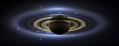
From Saturn, Earth a Pale Blue Dot

This image of Saturn released by NASA earlier this week really does drive home the fact that our planet and all of us are impossibly tiny on a universal scale (and this is just the view from our own solar system). Strange and (to me anyway) oddly comforting all at the same time. It's breathtaking to think of how much joy, misery, life can all be happening in such profusion across our planet - and that, from a distance, you'd be completely unaware, very likely never even know Earth exists.

This single image of Saturn consists of 141 wide-angle images taken by NASA's Cassini spacecraft. In addition to showing how Saturn would look to the human eye, it also shows Saturn and its inner ring system, as well as Earth, Venus and Mars, in stunning detail. 

This photo is part of the “Wave at Saturn” campaign NASA launched this past summer. Announcing that it would be shooting an image of Earth from Saturn, NASA invited the public to find Saturn in the sky, wave at the ringed planet, and share pictures via the Internet while Cassini simultaneously captured these images.  “In this one magnificent view, Cassini has delivered to us a universe of marvels,” Carolyn Porco, Cassini’s imaging team lead said of this image. “And it did so on a day people all over the world, in unison, smiled in celebration at the sheer joy of being alive on a pale blue dot.”

Photos released by NASA, November 2013
Image Credit: NASA/JPL-Caltech/SSI

Wednesday, November 13, 2013

First Ice on Puffer's Pond

First ice of season forming on Puffer's Pond, 11/13/2013, 7:30 am
(Photo by S. Vardatira)
Despite being a brilliantly sunny, blue sky morning, the day started out anything but warm. Winter has settled in the Valley (at least for a few days), and making the adjustment from the 40 and 50 degree days of last week to the plunging cold of last night and this morning is challenging. I'm not sure why it's so much easier to put up with the cold (and much colder) in mid-winter than it was this morning, but that's just the way it is. In fact, a 20 degree morning in January might not actually seem so bad. It's all relative. Other than one jogger that passed by, along with the sporadic car on State Street, not another human was in evidence at Puffer's Pond South Beach this morning. I did glimpse a duck paddling lazily in the open water near the marshes on the east side of the pond, but if there were others around, they were well hidden. Most of the trees have dropped their leaves, but a few are still hanging onto their foliage, which rustled gently in the light breezes. As I had anticipated (there would be no other reason to venture out in the cold this early!), ice has started to form near the shore and wherever the water is particularly shallow. Even from a distance I was able to identify the patches of ice by the swaths of leaves frozen on the surface. Where it's not frozen, the leaves have floated away, leaving the water dark and clear. Air temperature: 24.6°F.

Friday, November 8, 2013

Gray Skies Beautiful

Gray Sky Beautiful, Hadley MA - 11/7/2013
(Photo by S. Vardatira)
Farmhouse Under a Gray Sky, Hadley MA - 11/7/2013
(Photo by S. Vardatira)

Setting Sun, Amherst MA - 11/7/2013
(Photo by S. Vardatira)
When it comes to describing a beautiful vista, "gray skies" is not the term that usually springs to mind. But yesterday in the valley we had exactly that - starkly beautiful layers of undulating clouds in varying shades of gray (stratocumulus I would guess), stretching out from our hill-bounded horizon in every direction. I ended up ignoring my mid-day errands and work as I drove away from town and towards farmland to get a more expansive view. At one point when I had exited my car to take pictures, a police cruiser pulled up and asked if everything was okay. I nodded "everything's great," and gestured with my camera towards the sky. The officers followed my gaze, nodded in appreciation, and then waved good-naturedly as they headed on their way. "Carry on," they called as they drove off, "enjoy your day."  And so I did.

Along with Prayers and Donations, Time for Action on Climate Change


To put any storm we may experience this winter into perspective, Super Typhoon Haiyan just crashed into the Phillipines with sustained winds of 195 mph and gusts as strong as 235 mph, making it probably the strongest tropical cyclone to hit land anywhere in the world in recorded history. More than 125,000 people nationwide were moved to evacuation centers, and damage is likely to be significant. Last year, December's Typhoon Bopha, with sustained winds of 175mph, killed 1,100 people in the country, and, compounding the misery and loss, just last month an earthquake hit the central Philippine island of Bohol, killing 222 people. The Philippines is considered one of the most vulnerable countries to climate change. So in addition to holding good thoughts and prayers for everyone affected, we can also help by contributing to relief efforts and urging U.S. action on climate change.

Once it passes through the Philippines, Haiyan is likely to head back out into the South China Sea over the weekend, where it may well strengthen once again before heading toward the Vietnamese coast.